ROAD

VESTRA Road works alongside with AutoCAD. The application provides numerous Manager and Wizard interfaces to support users in accomplishing design tasks and creating optimized solutions. Whether it be urban or rural planning: VESTRA Road guides you through your entire workflow and lets you concentrate on optimal engineering even with the most complex projects.
Characteristics
- Powerful alignment capabilities for road and highway design using PVIs or elements, automatically taking constraints into account
- Provides Alignment Manager and Wizards for the design of intersections, roundabouts, and turning facilities
- Swept curve module for vehicle simulation and design evaluation
- Cross section design using components at the click of a mouse button
- Extensive built-in libraries and user-friendly Horizon Manager in cross section
Characteristics - Details
Alignment creation
- Easy alignment creation using PVIs with takeover of road edges and distances; interactive editing or PVI wizard interface where radius and clothoid values can be entered
- Designing aligments at the cutting edge using elements like circular curves, clothoids. tangents, taking constraints and modifications into account
Alignment Manager
- Provides an overview of alignments, parallels, sequence calculations, and annotations
Evaluation
- Checks lines according to the German guideline RAA, RAL, RASt, etc. upon calculation
- Calculates the rate of carvature
Swept curves
- This module contains design vehicles of the German guidelines as well as example vehicles of the manufacturers of MAN, Scania, Kässbohrer, Mercedes-Benz, and Schörling. Custom vehicles can be created and added to the library. Detailed vehicle angle reporting is integrated.
Intersection design
- Comfortable design options for junctions and intersections including triangular islands, divisional islands, left turns, or barred areas; automated adjustment to edge conditions
Roundabouts
- Create roundabouts with any number of arms quickly and easily. Choose from three basic types of junctions that can be adjusted to fit the situation
Turning facilities
- Use all types of turning facilities of the German standard RASt 85/95 and easily add them to an alignment.
Development facilities
- Design parking bays, bus turnouts, roadway tapers, pedestrian crossings, and space for trees.
Development facilities
- Design parking bays, bus turnouts, roadway tapers, pedestrian crossings, and space for trees.
Alignment annotation
- Representation and annotation of alignments in accordance with guideline RE85, RE 2012, e. g. alignments with names and numbers, main points and intermediate points, PVIs in plan, high and low points, cross falls in plan, cross sections in plan
Sequence calculations
- Calculation of alignment intermediate points with output of orthogonal and polar stake-out values to the graphical database or as a control list
- Calculation of perpendicular distances between alignments, alignment intersections, divisional islands, calculation of chord polygons and cross section lines
- Conversion of alignments to polygons to quickly lay out entire junctions as areas or lines
- Complex calculation of intersection points where alignments intersect
- Calculation of coordinates for bridge structures
- Constraints analyses with respect to single points/mouse position or sets of points
Road surface
- Heights and widths of roadways from manual values or from references to other alignments or gradients enable to take outside constraints into account.
- Design gradients and cross sections in multiple windows of plan, profile, and section views, using constraints from the graphical database or from other alignments
Vertical alignment
- Interactive design of gradients in profile using PVIs and constraints; in addition to the main alignment, further gradients are available for road surface height references, for structures, verges, and slopes
- Automatic generation of curb return curve
- Calculation of stations and 3D coordinates on available gradients at predefined intervals of height differences
- Calculation of differences in height of two gradients with maximum deviation data, with list output
Profiles
- Automatically generate profiles. Use menus and preview windows to set display and annotation parameters. Show additional alignments, gradients, and sewers. Also, any number of property strings from different data sources can be displayed. Additional features: widening of string annotation, property strings, and automatic annotation of PVIs with framing
Horizon Manager
- User-friendly Horizon Manager with various measuring and evaluation tools
Standard cross section
- Use a wizard-like interface to create a standard cross section from the existing data; employ built-in catalogs for design details (kerbs, special slope types, formation, drainage)
Cross sections
- Choose from a catalog of components by mouse-clicking; the catalog is customizable for increased flexibility.
- Constructions can be adjusted to fit every cross section.
- Components are selected depending on the existing data (conditions), e. g. cut or embankment.
- In a cross section, users can refer to lines in the graphical database, to gradients of multiple alignments, e. g. for gutters or ditch bottoms.
Cross section plans
- Output of single or several profiles to a plan
- Several automated layout options such as slope annotation, output of symbols and constraints
Comparing horizons
- Compare two horizons or cross section areas and compute the deviation (e. g. built road / planned road).
Volume calculations
- Calculate volumes in plan for sections and areas, in DTM for volumes from prisms, and in cross section from profiles.
Mass diagrams
- Draw mass diagrams to summarize cut and fill quantities based on cross sections; helps to optimize mass-haul.
Recalculation
- When making additional changes to alignments, gradients, terrain profiles, or to the road surface, subsequent calculations (e. g. volume computations) will be automatically updated.
Alignment creation: PVIs/elements
PVIs or elements can be used for alignment creation. Employ PVIs to easily create an alignment free-hand, taking road edges and distances from existing data into account. Creating alignments using elements provides the cutting edge of alignment design capabilities in VESTRA Road. In addition to elements like circular curves, clothoids, and tangents, outside constraints and interrelationships are automatically included and considered with every alignment modification.
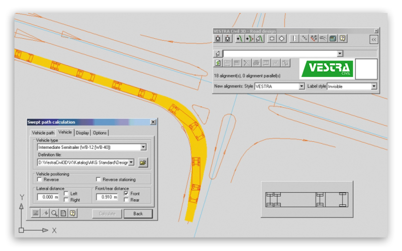
The swept curve module offers the latest technology for a realistic representation of the rideability of road infrastructure, e. g. roundabouts. It contains design vehicles conform to German guidelines and a variety of example vehicles. Also, users can define customized vehicles with wheelbase, maximum steering angle, etc. A detailed vehicle turn report provides a comfortable means to evaluate rideability and helps you find the optimal solution even for the most complex assignments.